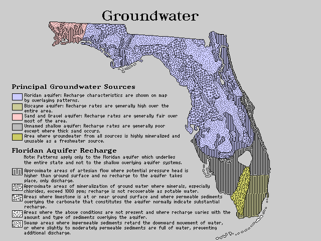
Labels:text OCR: Groundwater Principal Groundwater Sources Floridan aquifer: Recharge characteristics are shown on map by overlaying patterns. Biscayne aquifer: Recharge rates are generally high over the Sand and Gravel aquifer: Recharge rates are generally fair over entire area. most of the area. Unnamed shallow aquifer: Recharge rates are generally poor except where thick sand occurs. Area where groundwater from all sources is highly mineralized and unusable as a freshwater source. Floridan Aquifer Recharge Note: Patterns apply only to the Floridan aquifer which underlies the entire state and not to the shallow overlying aquifer systems. Approximate areas of artesian flow where potential pressure head is higher than ground surface and no recharge to the aquifer takes place, only discharge. Approximate areas of mineralization of ground water where minerals, especially chlorides, exceed 1000 ppm; recharge is not recoverable as potable water. Areas where limestone is at or near ground surface and where permeable sediments buerlying the carbonate that constitutes the aquifer normally indicate substantial recharge. Areas where the above conditions are not present and where recharge varies with the amount and type of sediments ouerlying the aquifer. Swamp areas where impermeable sediments retard the downward movement of water, or where slightly to moderately permeable sediments are full of water, preventing additional discharge.